According to the State Emergency Service of Ukraine, on 29 June at 12:35, the debris remaining from wood felling and forest litter burst into flames during forest clearing for laying a railroad on the territory of the Lubyansk forestry in the exclusion zone, based on preliminary data. The fire quickly spread to an area of about
As of 12:30 p.m. on 30 June, the fire area is about
According to the State Agency of Ukraine on Exclusion Zone Management the State Specialized Enterprise ‘Ecocentre’ enhanced radiation monitoring in the exclusion zone. Data on the equivalent gamma dose rate (EDR) and radionuclide content in the air of the fire area are continuously analyzed in a prompt manner.
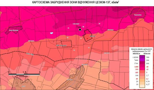
SCHEMATIC MAP OF EXCLUSION ZONE CONTAMINATION WITH CESIUM-137, kBq/m2
There are three automated radiation monitoring system (ARMS) points near the fire area. According to the ARMS points, the equivalent gamma dose rate in the fire area as of 19:00 on 29 June 2017 did not significantly change, and current EDR values vary within limits usually observed for each point (Table 1). The EDR reference levels have not been exceeded.
Table 1. Exposure dose rate (EDR) in the fire area in the period from 29 June 2017 at 19:00
| No. | ARMS point | EDR, nSv/h | Reference levels, nSv/h | ||
| minimum | average | maximum | |||
| 1 | Vektor | 130 | 140 | 155 | 270 |
| 2 | Buryakivka | 2720 | 2800 | 3000 | 7500 |
| 3 | Korogod | 120 | 125 | 130 | 260 |
The Ecocentre mobile response force with aspiration and dosimetry devices has been engaged for prompt evaluation of radiation situation since the fire beginning.
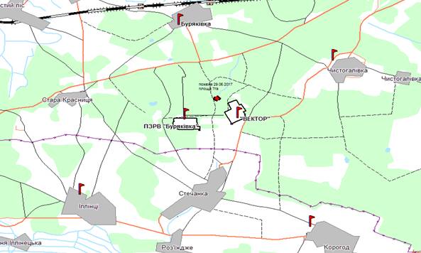
For reference: radiation background in the exclusion zone is monitored by the automated radiation monitoring system (ARMS) in continuous mode at 39 points (Figure 1). The data are routinely transferred to the control center every hour and every two minutes in the event of an emergency.
Radiation survey has shown that 137Cs activity concentration in the air of the fire area was 2.5Е-2 Bq/m3 on the fire line at 19:00 on 29 June 2017. This activity concentration is 2.5 times higher than the reference level established in the ‘Basic Reference Levels, Exemption Levels and Action Levels for Radioactive Contamination of Objects in the Exclusion and Resettlement Zone’ (RL =1.0Е-2 Bq/m3 for 137Cs).
The equivalent dose rate at a distance of
Considering that the fire area is located near the ‘western radioactive trace’ with high levels of contamination, the staff are strongly recommended to use respiratory protective means.
The radiation situation is under control, further information will be promptly clarified and provided.